ERETZ images

Collections | Contact | Chat (new)

Southern Alps and Glaciers of New Zealand

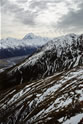
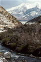
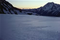
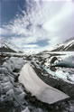
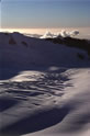
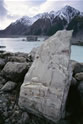
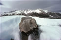
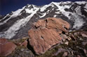
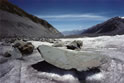
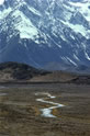
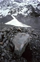
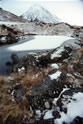
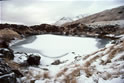
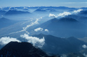
The mountain peaks and ranges and associated temperate-zone glaciers and glacier valleys of the Southern Alps of New Zealand are of considerable geological and climatological importance. In the context of global warming the glaciers in particular are currently subjects of much international scientific research. The Southern Alps are also justifiably regarded worldwide as spectacular and unique attractions and destinations for tourists, back-packers, mountaineers, skiers and wing and other gliders, as well as for artists in many media including feature movie-making.

Slideshow | Thumbnails

Northward view of the Tasman Glacier showing rock debris spilt down the Hochstetter Glacier (entering lower left) from the 1991 rock avalanche from the east side of the high peak of Mt Cook. The avalanche was estimated to total 10 million cubic metres and reduced the height of the mountain by 10 metres. Upper-left picture, the Rudolf Glacier enters the Tasman. Northward view of confluence of Tasman Glacier (left) and Murchison Glacier (right) with Malte Brun Range between. The Hochstetter Glacier is seen entering from the mid-left; the Ball Glacier from the lower left. Fox Glacier: in the foreground is the part of the neve contributed by the Albert Glacier, on the west side of Main Divide of the Southern Alps, just north of Mt Cook and Mt Tasman (see images 33 and 34). Dramatically shown here in the evening cross-light are the crevass patterns formed by the upheaving pressure of the neve ice. The snowflat uppermost on the left in this view is a popular landing place for ski-planes for tourists to view the entire neve and, as seen in images 33 and 34, the steep icefall of the middle and lower part of the glacier. Mt Cook summit and heavily glaciered west face, in evening light in an aerial view from above the Empress Glacier. Tasman Valley south of terminal face of Tasman Glacier. Mt Cook on Main Divide in distance. Tasman River winds southward on the valley floor and receives the Hooker River from the Hooker Valley entering on the left. Burnett Mountains in foreground. Mt Cook, on Main Divide, in distance; Burnett mountains in foreground; Tasman Valley in between. Mt Cook: South face and low, middle and high peaks in northward view. The first ascent of the south face was made in 1962. The first ascent of the technically very demanding south ridge was one of many historic firsts achieved by Edmund Hillary in the Southern Alps. On that ascent, of 6 February 1948, Hillary was one of a team of 4 led by the legendary Mt Cook guide Harry Ayres.  Tributary glacier valley and river entering (see image 14) the west side of the lower Tasman Valley. The tributary river is seen here being crossed by the only road access to Mount Cook Village and its famous Hermitage Hotel. The Blue Stream: in western lateral moraine towards lower end of Tasman Glacier. Sealy Range in distance. Tasman Glacier: southward view of lower neve in evening light disclosing flow lines in Tasman Glacier: Wind-blown granular ice-mound at lower end of glacier. Hochstetter Dome (on north head of Tasman Glacier neve) and Mt Elie de Beaumount and Mt Walter. Tributary glacier river entering lake Pukaki, seen in wide-view in image 14 in which this tributary enters from left picture. Southward view of braids of Tasman River, on Tasman Valley floor, entering Lake Pukaki, one of New Zealand's most important hydroelectric reservoirs. Image 44 in this collection is a closer, northward, view of the Tasman River entering Lake Pukake. Tasman Glacier: surface and lateral moraine in an eastward crossview, with Liebig Range in background. The ice exposed here extends vertically hundreds of meters to the glacier valley floor. The movement of the ice mass is from left to right. Image 21 of this collection provides a wider crossview at the junction of the Tasman and Murchison Glaciers. Tasman Glacier Valley: Mt Cook Airport building and airstrip in mid-upper foreground; Burnett mountains in midground; Lake Tekapo at foot of most distant mountain range. Southward view of melt-pool on the lower Tasman Glacier. The ice bridge, visible left-of-centre of the distant waterline here, is portrayed close-up by image 42 of this collection. Ice-forms on lower Tasman Glacier (southward view). Tasman Glacier: northward view of a deeply cutting melt-stream in mid summer. The median moraine covering of the glacier ice is thin here.  Mt Malte Brun in distance. Tasman Glacier: median moraine melt-pool, showing algae and rock-flour on submerged rocks. In the distance is lateral moraine of the west wall of the glacier; more disantly, peaks of the Main Divide. Tasman Glacier: surface and lateral moraine in eastward crossview to Malte-Brun Range (left) and Liebig Range (right) with Murchison Glacier entering between. The ice exposed here extends vertically hundreds of meters to the glacier valley floor. The movement of the ice mass is from left to right. Tasman Glacier (left) converging with Rudolph Glacier (right). Southward view from the rock-covered De La Beche ridge (see also image 26) which separates the two glaciers here. Mt Cook, mid-right, in distance. Fox Glacier: westward view of small part of mid-neve in evening light. North-eastward view of lower part of Tasman Glacier. Naturally sculptured rock slab being transported south on median moraine. Malte Brun range in background. Tasman Glacier: moraine boulder being carried southwards on mid-glacier ice. Liebig Range in background. Weathered rocks on De La Beche ridge which separates the Tasman and Rudolph glaciers. Two steep glaciers on the Main Divide in background. The red colouration of the surface of the rocks shown here takes 300-400 years of iron-oxidative weathering to develop. Tasman Glacier: southward view of lower reaches. Ice-scored boat-shaped boulder in foreground. Ben Ohau Range on right; Burnett Mountains on left. Mt Aylmer: eastward view of summit from rock ridge, populated by green, grey and black lichens, near Hochstetter Dome above Tasman Glacier neve. Tasman Glacier: upper neve with bergschrund on south slope of Hochstetter Dome. From left to right in background are Mts Green, Walter and Elie de Beaumont. Tasman Glacier Valley in summer: Tributary of Tasman River south of vegetation-covered terminal moraine. Grey lateral moraine and Liebig range in background. Tasman Glacier terminal face blackened by surface moraine rockfall, melting in summer sun. Glacier rock-flour whitens the terminal lake and the moraine boulders in the foreground. Mt Cook in far distance. Tasman Glacier: westward view of middle and lower neve, with Tasman Saddle Hut (red) on rocky outcrop at lower right. Malte Brun range casts a shadow from the left; the Main Divide is seen in the distance. Eastward view of Fox Glacier and its extensive neve arising on the west side of the Main Divide of the Southern Alps. Mt Tasman is seen at top-right. The remarkable crevassing of the upper neve of Fox Glacier is shown in evening cross-light in the west-looking, much closer view which is image 3 of this collection.  South-eastward view of Fox Glacier neve. Mt Cook summit is seen piercing hogsback clouds. The summit of Mt Tasman, to the left of Mt Cook here, is covered by cloud. The remarkable crevassing of the upper neve is strikingly shown in evening cross-light in the west-looking, much closer view which is image 3 of this collection.  Weathering, partly by water-ice expansion splitting, of rock above neve of Tasman Glacier. Southern Alps: view to south-west from above Main Divide. Tasman Glacier: facetted boulder on surface moraine of lower reaches of glacier. Lateral moraine with fan-shaped ice-spill from Main Divide of Southern Alps in distance. Tasman Glacier: westward evening view across crevassed upper neve, through Tasman Saddle to sunlit peak of distant Mt Sibbald. Southern Alps: westward view at sunset, from above the Baker Saddle on the Main Divide. The summit of Mt La Perouse, located 5 km directly west of Mt Cook, is seen mid-right; Dilemma Peak, lower left. On the horizon in the mid-left of the frame appears the solitary peak of Mt Aspiring (9,951 ft). Close below and to the right of Mt Aspiring are seen Mt Brewster (8,448 ft) on right and Mt Armstrong on left. Tasman Valley: southward view of west-side tarn in winter with lichen-covered rock and sub-alpine vegetation including tussock and the dark, tangled and prickly New Zealand native shrub, Matagouri. Tasman Valley: Southwest view of west-side tarn in winter with sub-alpine tussock vegetation. Ben Ohau range in distance. Tasman Glacier: Southward view, in summer, of melt-pool and rapidly-thinning ice-bridge shown distantly by image 17 of this collection.    Tasman Glacier: lichens on rocks of terminal moraine in foreground of southward view of Tasman Valley Northward view of Tasman River valley showing braids of the river entering the northern end of Lake Pukake, New Zealand's largest man-made hydro-electric storage lake. The cloudiness of the water in the foreground is due to glacial rock-flour. Mt Cook is seen in the far distance centrally in the picture. Image 14 in this collection is a southward view of the Tasman River valley and Lake Pukake with tributary rivers entering from both sides of the valley. Mt Brewster (7813 ft) and its 2-kilometre-long, very picturesque, “fairyland”, glacier located on the Main Divide between Mt Cook in the north and Mt Aspiring in the south (see image 39). In this view the cavernous exit of the glacial melt-waters is seen forming the stream which passes westward to the small glacier lakes which end in a 900 metre cataract eventually entering the Haast River on the West. The striking rusty iron-stone stratification in the foreground is a strong feature of much of the base-rock south of the Brewster Glacier lakes. The black stripe running to the snout of the glacier terminal face is made up of rock debris forming the median moraine. Mt Brewster (7813 ft) and its 2-kilometre-long, very picturesque, “fairyland”, glacier located on the Main Divide between Mt Cook in the north and Mt Aspiring in the south (see image 39). In this view the cavernous exit of the glacial melt-waters is seen forming the stream which passes westward to the small glacier lakes which end in a 900 metre cataract eventually entering the Haast River on the West. The striking rusty iron-stone stratification in the foreground is a strong feature of much of the base-rock south of the Brewster Glacier lakes. The black stripe running to the snout of the glacier terminal face is made up of rock debris forming the median moraine. Southeastward view, from above the Main Divide, of the lower valley of the Hunter River whose watershed includes the east side of Mt Brewster (7813 ft) which is located on the Main Divide, south of Mt Cook and north of Mt Aspiring. The braided Hunter River ends by narrowing, then entering the head of Lake Hawea.

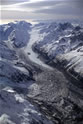
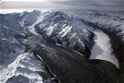
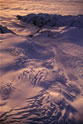
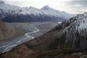
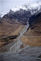
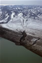
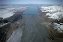
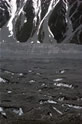
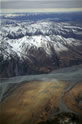
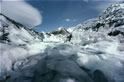
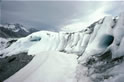
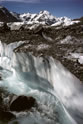
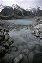
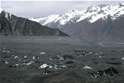
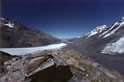
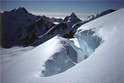
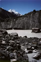
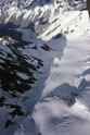
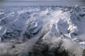
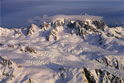
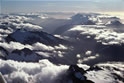
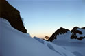
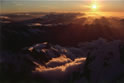
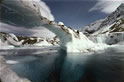
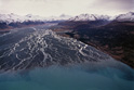
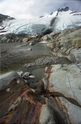
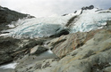
The present collection of images in geographic essay format arrestingly portrays iconic peaks and glaciers and other special geological features of the most famous and most visited part of the Southern Alps; that which includes Mount Cook and the Tasman, Franz Josef and Fox Glaciers.

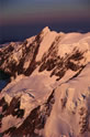
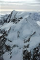
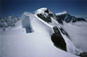
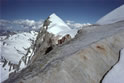
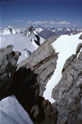
In this collection the principal images of Mount Cook are numbers 4, 5, 6, 7 and 31.

Mount Cook, "Aoraki" in the Maori language, is New Zealand's highest (3,754 meters / 12,316 feet) and best-known peak and among the world's most technically challenging for climbers. It was a favourite of the New Zealand mountaineer Sir Edmund Hillary (1919-2008) whose many ascents of it contributed greatly to his preparation for the first successful attempt on Mount Everest when, as a member of the 1953 British Everest Expedition led by Sir John Hunt, he was chosen together with the Nepalese sherpa Tenzing Norgay for the two-man final assault on the summit on 29 May.

Many of the 43 images selected for this collection were included in the one-man large-format exhibition "Heavens and Firmament" which was mounted for fund-raising for the Stop Polio Campaign of Save The Children Fund NZ in the summer of 1981 at New Zealand's Auckland Museum; and in 1986 at New Zealand House,The Haymarket, London and, by special invitation immediately following, at the Natural History Museum, Kensington, London, when for its public use in Geological education it was given scientific captions throughout and re-titled "Valley Glaciation in the Southern Alps of New Zealand"

In the years following, the original essay has been considerably updated. However, only 4 of the images in the present collection have been permitted by their New Zealand photojournalist creator to be published; that being in "New Zealand Geographic" magazine and, in the case of image number 42, in the book "New Zealand Geographic - 100 Best Images" Kennedy Warne (ed.) pub. D. Bateman 1995.

The first online presentation (beginning 29 May 2008) of this unique collection is aimed at making the images generally available to mountaineers, scientists, first-time and continuing visitors to New Zealand, artists, collectors and publishers, and for large-format display in museums, galleries and other public venues, as well as for private home decor and deployment in commercial settings.